July 9, 2020 – Washington Co., WI – The National Weather Services is reporting a line of strong thunderstorms moving through Washington, Dodge and Fond du Lac Counties this Thursday afternoon.
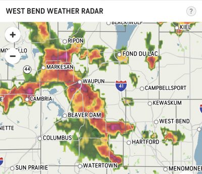
At 1:49 p.m., radar indicated strong thunderstorms located along a line extending from near Ripon to near Hartford.
Movement was north at 20 mph. Winds of 40 to 50 mph and penny size hail are possible with these storms.
Locations impacted include… Fond Du Lac, West Bend, Waupun, Ripon, Jackson, Mayville, Slinger, North Fond Du Lac, Kewaskum, Germantown, Lomira, Campbellsport, Theresa, Oakfield, Rosendale, Brandon, Southern Lake Winnebago, Taycheedah, Addison and Ashford.
This will be the second line of storms today as temperatures dropped around 8 a.m. and heavy rains pummeled the area. There was flooding reported in Fond du Lac. The rains were accompanied by lightning strikes and loud cracks of thunder.