


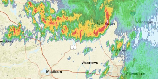
August 7, 2021 – Washington, Dodge, Fond du lac counties – According to the National Weather Service there are strong thunderstorms moving through Washington, Dodge and Fond du lac counties.
According to the National Weather Service:
At 1001 PM CDT, Doppler radar was tracking strong thunderstorms along
a line extending from near North Fond Du Lac to near Waupun to near
Randolph. Movement was southeast at 35 mph.
HAZARD…Winds in excess of 30 mph and pea-size hail.
SOURCE…Radar indicated.
IMPACT…Gusty winds could knock down tree limbs and blow around
unsecured objects. Minor damage to outdoor objects is
possible.
Locations impacted include…
Fond Du Lac, West Bend, Beaver Dam, Hartford, Waupun, Ripon, Jackson,
Mayville, Slinger, North Fond Du Lac, Columbus, Kewaskum, Horicon,
Juneau, Lomira, Campbellsport, Markesan, Theresa, Newburg and
Hustisford.
People attending The Hartford Airport, and The Iron Ridge Firemans Picnic should seek safe shelter immediately. If outdoors, consider seeking shelter inside a building.
Torrential rainfall is also occurring with these storms and may lead
to localized flooding. Do not drive your vehicle through flooded
roadways.
Frequent cloud-to-ground lightning is occurring with these storms.
Lightning can strike 10 miles away from a thunderstorm. Seek a safe
shelter inside a building or vehicle.