


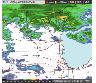
March 15, 2026 – Washington Co., Wi – Neighbors across Washington County and the rest of southeastern Wisconsin are under a Winter Weather Advisory, which could be upgraded to a Winter Storm Warning as a much-anticipated system moves across the state. More details below. Feel free to share your photos.
According to the National Weather Service:
Through Mid-Morning Today:
Winter Weather Advisory through this morning for snow turning to a wintry mix of sleet/freezing rain with a glaze up to a quarter an inch of ice on top of the 1-3 inches of snow that has already fallen.

Wintry mix may end earlier, and the Winter Weather Advisory may be canceled early if this occurs.
Milder temperatures south of I-94, w/ some non-accumulating wintry mix to rain this morning.
Mid-Morning – This Afternoon:
Milder temps spread northward this afternoon with breaks in precip.
Expect intermittent light wintry mix/snow into central WI where temps hover around freezing.
Scattered rain chances and isolated thunderstorms will affect much of southern WI, where temperatures will be in the 40s and 50s.
Areas closer to the WI/IL border and southeast WI may see a few isolated thunderstorms capable of producing small hail.
This Evening – Mon Afternoon:
Winter Storm Warning: North of a line from Beloit to Cedar Grove, expect a transition from rain to wintry mix to snow through the evening.
Snow Totals: 6–10 inches, with gusty northwest winds that may approach blizzard conditions, mainly toward central WI.

Hourly Snow Rates: The highest hourly snow rates are expected after midnight through daybreak with rates of 0.5 to 1 inch per hour.
Snow characteristic: Snow will start off wetter, which may stick more to trees and powerlines. As temperatures drop, expect it to transition toward drier snow, making it more susceptible to blowing and drifting with the stronger winds.
Winter Weather Advisory:Southeast WI, wintry mix changing to snow.
Milder temps, a later start time after 10 pm tonight, and lower snow rates (less than 0.5 inch per hour) will result in less snow for southeast WI, but still expect 2-5 inches across this area.
Today
Rain or freezing rain, becoming all rain after 8am. High near 43. Breezy, with an east wind 15 to 20 mph becoming north in the afternoon. Winds could gust as high as 35 mph. Chance of precipitation is 100%. Total daytime ice accumulation of less than a 0.1 of an inch possible.
Tonight
Rain, snow, freezing rain, and sleet before 3am, then snow, possibly mixed with sleet between 3am and 4am, then snow after 4am. The snow could be heavy at times. Widespread blowing snow, mainly after 4am. Low around 18. Windy, with a north wind 25 to 30 mph, with gusts as high as 40 mph. Chance of precipitation is 100%. New ice accumulation of less than a 0.1 of an inch possible. New snow and sleet accumulation of 1 to 2 inches possible.

Monday
Snow, mainly before 1pm. The snow could be heavy at times. Widespread blowing snow, mainly before noon. High near 21. Wind chill values between zero and 5. Windy, with a northwest wind 25 to 30 mph, with gusts as high as 40 mph. Chance of precipitation is 80%. New snow accumulation of 1 to 2 inches possible.
Monday Night
Mostly cloudy, then gradually becoming mostly clear, with a low around 4. Wind chill values between -10 and zero. Blustery, with a northwest wind 15 to 20 mph decreasing to 10 to 15 mph after midnight. Winds could gust as high as 30 mph.
Tuesday
Sunny, with a high near 21. Northwest wind around 10 mph.
Tuesday Night
Snow likely, mainly after 1am. Mostly cloudy, with a low around 14. South wind 5 to 10 mph. Chance of precipitation is 70%. New snow accumulation of less than one inch possible.
Wednesday
A 20 percent chance of snow before 1pm. Cloudy, then gradually becoming mostly sunny, with a high near 41. South wind around 10 mph.
Wednesday Night
A 20 percent chance of rain after 1am. Mostly cloudy, with a low around 32. Southwest wind around 5 mph.
Thursday
Sunny during the morning, then mostly cloudy during the afternoon, with a high near 45.