


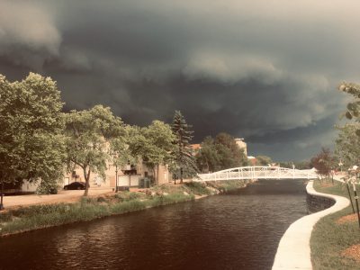
April 14, 2026 – Washington County, Wi – The National Weather Service has issued a Tornado Watch for Washington County, WI, and neighboring Waukesha County until 10 p.m. Neighbors are reporting rolling thunder and lightning strikes as storms move east across the area.
According to the National Weather Service:
..A SEVERE THUNDERSTORM WARNING REMAINS IN EFFECT UNTIL 715 PM CDT FOR NORTHERN WAUKESHA…SOUTHERN WASHINGTON…NORTHERN JEFFERSON AND SOUTHERN DODGE COUNTIES…
At 618 PM CDT, a severe thunderstorm was located near Watertown, moving east at 35 mph.
HAZARD…Tennis ball size hail and 60 mph wind gusts.
SOURCE…Trained weather spotters report 1 inch hail in both Watertown and Hartland.
IMPACT…People and animals outdoors will be injured. Expect hail damage to roofs, siding, windows, and vehicles. Expect wind damage to roofs, siding, and trees.

Locations impacted include…
Waukesha, New Berlin, Brookfield, Menomonee Falls, Watertown, Hartford, Pewaukee, Sussex, Hartland, Jefferson, Delafield, Jackson,
Elm Grove, Lake Mills, Slinger, Waterloo, Wales, Okauchee Lake, Germantown, and Oconomowoc.
PRECAUTIONARY/PREPAREDNESS ACTIONS…
A Tornado Watch remains in effect until 1000 PM CDT for south central and southeastern Wisconsin.
For your protection move to an interior room on the lowest floor of a building.