


February 18, 2022 – Washington County, WI – The National Weather Service has issued a special weather statement for the following counties:
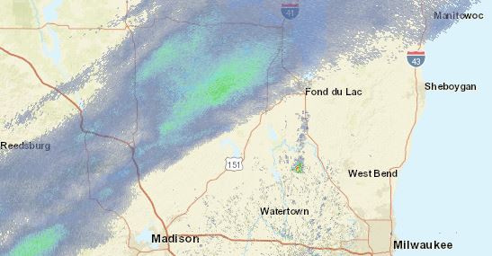
Marquette-Green Lake-Fond du Lac-Sheboygan-Sauk-Columbia-Dodge-
Washington-Ozaukee-Iowa-Dane-Jefferson-Waukesha-Milwaukee-
Lafayette-Green-Rock-Walworth-Racine-Kenosha-
Including the cities of Montello, Westfield, Oxford, Neshkoro,
Endeavor, Berlin, Princeton, Markesan, Fond Du Lac, Plymouth,
Sheboygan Falls, Howards Grove, Oostburg, Baraboo, Reedsburg,
Prairie Du Sac, Sauk City, Portage, Columbus, Lake Wisconsin,
Lodi, Beaver Dam, Waupun, Mayville, West Bend, Germantown,
Hartford, Mequon, Cedarburg, Grafton, Dodgeville, Mineral Point,
Barneveld, Madison, Watertown, Fort Atkinson, Jefferson,
Waukesha, Brookfield, New Berlin, Menomonee Falls, Muskego,
Milwaukee, Darlington, Shullsburg, Benton, Belmont, Argyle,
Blanchardville, Monroe, Brodhead, Janesville, Beloit, Whitewater,
Delavan, Elkhorn, Lake Geneva, East Troy, Racine, and Kenosha
1221 PM CST Fri Feb 18 2022

...Burst of Moderate to Heavy Snow May Affect Southern
Wisconsin...

Snow showers associated with a passing arctic cold front will
affect southern Wisconsin late this afternoon and early evening,
mainly between 5 pm CST and 8 pm CST. A burst of moderate to
briefly heavy snow may occur in the snow showers, quickly dropping
the visibility down to 1/4 to 1/2 mile. This could result in a
quick snow accumulation of under an inch on untreated roads,
resulting in hazardous travel conditions and accidents.

Evening commuters should be prepared to slow down during this
burst of heavier snow, and save lives. Be weather aware this
evening.
The NWS has also issued the following hazardous weather outlook for the following counties:
Marquette-Green Lake-Fond du Lac-Sheboygan-Sauk-Columbia-Dodge-
Washington-Ozaukee-Iowa-Dane-Jefferson-Waukesha-Milwaukee-
Lafayette-Green-Rock-Walworth-Racine-Kenosha-
Strong southwest winds gusting 45 to 50 mph are expected to
continue late this afternoon, becoming northwesterly this
evening. A Wind Advisory remains in effect through late tonight.

A brief period of snow showers may quickly reduce the visibility
to one half mile or less late this afternoon and early evening.
Rapid snowfall of up to an inch may result in slippery spots
developing on untreated roads for the late afternoon commute. Be
weather aware if you have to head out late this afternoon and this
evening and slow down and try to avoid driving in the snow as it
moves through.

Strong winds and falling temperatures will cause wind chills to
drop into the negative teens tonight into Saturday morning.